|
Liquefaction |

|

|
The method of Seed & Idriss (1982) is the most known and used of the simplified methods and requires only the knowledge of few geotechnical parameters: the granulometry, the number of blows in the SPT test, the relative density, the unit weight.
To determine the value of the reducing coefficient rd is used the empirical formula proposed by Iwasaki and others (1978):
![]()
while for the corrective factor MSF in Table 1 is brought the value of this factor obtained by various researchers, among which Seed H. B. and Idriss I. M (1982).
Magnitude |
Seed H. B. & Idriss I. M. (1982) |
|---|---|
5.5 6.0 6.5 7.0 7.5 8.0 8.5 |
1.43 1.32 1.19 1.08 1.00 0.94 0.89 |
Table 1 - Magnitude Scaling Factor
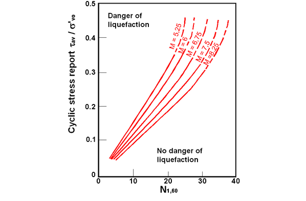
The liquefaction resistance CRR, is calculated as a function of the magnitude, the number of blows, the effective vertical pressure, the relative density.
By selecting the cases of terrains with liquefaction and no liquefaction during the earthquakes, a graphic (Fig. 1) is obtained.
Initially the correct number of blows at the desired elevation is calculated to take into consideration the lithostatic pressure through the following relation:
![]()
where:
Nm average number of blows in the penetration standard test SPT
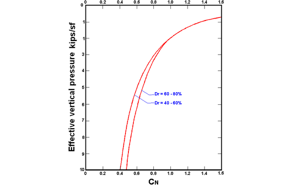
CN corrective factor calculated using the following expression:

where:
σ'vo effective vertical pressure;
Pa atmospherical pressure expressed in the same s'vo units;
n an exponent that depends on the relative density of the soil (Fig. 2)

Figure 1 – Correlation between CSR and N1.60

Figure 2 – Corrective coefficient CN
It was demonstrated that for an earthquake of a magnitude equal to 7,5 CRR is:
![]()
Is therefore applied :
![]()
if FS > 1,3 the deposit can not be liquefied
The Authors have specified that this procedure is valid for sand with D50 > 0,25 mm; for sandy silt and silts they suggest to correct afterwards the value of N1,60:
![]()
© GeoStru Software