|
Data import |

|

|
Import 3D model
Allows the import of text files that contain the three-dimensional information (x,y,z) of the points. The import system allows the import of text files in any format: it is enough to set the separator type (“,” or “;”), the first row to read and the numbers of the columns containing x, y and z. The command “File data extraction” applies a filter to the data contained in the text file and extracts the coordinates of the points on which to perform the triangulation.
Through the “Triangulate” button it is generated the digital model on which bi-dimensional verification sections can be created. The sections are exported for Slope using the “Assign the current section to Slope” button.
Import TriSpace sections
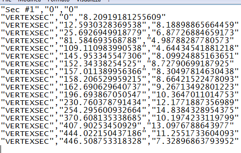
TriSpace is the topography software of GeoStru that allows the creation of elevation plans, contoured elevation plans, 3D representation, 2D and 3D sections. The sections are exported from TriSpace in text files with *.sec extension, having the following format: VERTEXSEC, x,y. In the figure below you can see an example file generated from TriSpace.

Example file generated from Trispace ready to be imported in Slope
Import DXF sections
The DXF must contain exclusively open polylines numbered from left to right, that define the topographic profile and the layers. Each polyline must belong to a specific LAYER.
Example: Profile polyline on LAYER=0, Layer 1 on LAYER=1, Layer 2 on LAYER=2, Groundwater on LAYER=GROUNDWATER.
Import sections from Penetrometric tests
The Dynamic and Static Probing software allow to connect the soil tests along a path and export them in an *.esp file. The esp file contains geometrical information (x,y,z) on the test and information on the test itself (number of blows, resistance, stratigraphy).
The topographical location is performed automatically, while the reconstruction of the stratigraphy is the responsibility of the operator, who will connect the layers belonging to the stratigraphic columns.
Import from LoadCap
LoadCap is a GeoStru software for the computation of bearing capacity and settlements of shallow foundations. For foundations on slopes it is necessary to perform the global stability analysis -the file exported from LoadCap contains all the information necessary to perform this analysis.
© GeoStru Software